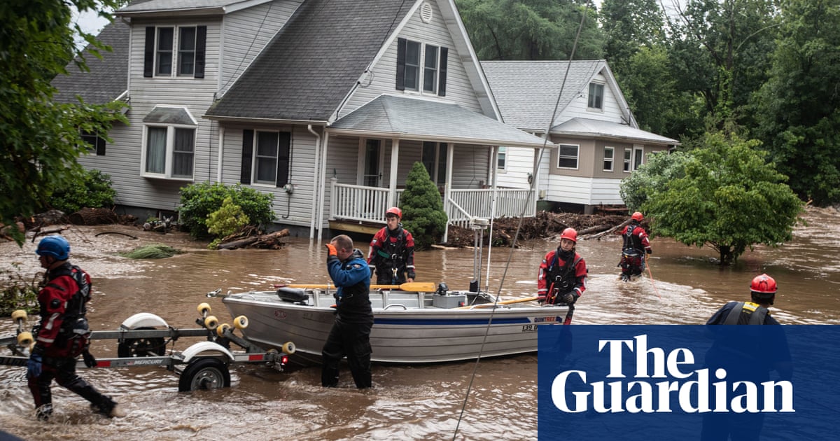
Deadly flooding in the north-east on Monday coupled with alerts over longer, hotter heatwaves set to boil much of the southern and western US kicked off a week of dangerous weather, as July warnings about the climate crisis intensify.
Rescue teams raced into Vermont after relentless, torrential rain drenched parts of New England and north-east overnight, washing out roads, forcing evacuations and halting some airline travel.
One person was killed in upstate New York as she was trying to leave her home and some in Ulster county said the flooding was the worst they’ve seen since Hurricane Irene, called the worst weather event in that county’s history, when it hit in 2011.
Roads collapsed in parts of the Hudson Valley and waves of water hit some areas with little warning, as the New York governor, Kathy Hochul, declared a state of emergency for Orange county, about 60 miles north of New York City.
Mike Cannon of Vermont Urban Search and Rescue said crews from North Carolina, Michigan and Connecticut were among those helping to get to towns on Monday that so far had been unreachable since storms hit late on Sunday.
Heavy downpours with possible flash flooding were forecast in parts of Connecticut, Massachusetts, New Hampshire and Maine after the flash floods had already ravaged parts of upstate New York and the Green Mountains region of Vermont.
US atmospheric scientists warned that although the destruction in American states might seem distant and unconnected from massive flooding disasters in India, Japan, China and Turkey this year, they have this in common: storms are forming in a warmer atmosphere, making extreme rainfall a reality right now. And the additional warming that scientists predict is coming will only make it worse.
“As the climate gets warmer we expect intense rain events to become more common, it’s a very robust prediction of climate models,” said Brian Soden, professor of atmospheric sciences at the University of Miami, adding: “It’s not surprising to see these events happening, it’s what models have been predicting since day one.”
A warmer atmosphere holds more moisture, which results in storms dumping more precipitation that can have deadly outcomes. Pollutants, especially carbon dioxide and methane, are heating up the atmosphere. Instead of allowing heat to radiate away from Earth into space, they hold onto it.
While climate change is not the cause of storms unleashing the rainfall, these storms are forming in an atmosphere that is becoming warmer and wetter.
Rodney Wynn, a meteorologist at the National Weather Service in Tampa Bay, said: “Warm air expands and cool air contracts. You can think of it as a balloon – when it’s heated the volume is going to get larger, so therefore it can hold more moisture.”
A weekend landslide in southern California that forced evacuations may have had heavy rain as a factor.
Meanwhile, tens of millions of people from Florida to California are bracing for more heatwaves.
A new three-day heat advisory was issued for south Florida on Monday morning, days after successive temperature records were broken in the Miami metropolitan area.
National Weather Service (NWS) officials said a buildup of dust in the atmosphere all the way from the Sahara desert was lowering rain chances and keeping temperatures elevated. The heat index in Miami was expected to reach 105F on Monday afternoon.
The city was already experiencing its hottest year on record, with 15 daily peak temperature records broken since 1 June. Air quality is down and record ocean heat is threatening more delicate coral reefs, depriving swimmers of cooling dips and making an oppressive summer even more uncomfortable.
With Gulf coast states sweltering and Texas in particular enduring an extremely hot early summer, the NWS has now warned Arizona, no stranger to scorching heat, to brace for an extreme week, especially in the Phoenix area.
Phoenix has experienced temperatures above 110F for 10 consecutive days, NPR reported on Monday.
And desert highs in northern Mexico are expected to spread into California and the south-west, the San Francisco Chronicle reported.
This week follows early July record global temperatures in what is predicted to be the hottest month in the US ever recorded, accelerated by the El Niño pattern, as the climate crisis continues to spiral.
And Antarctic sea ice levels reached record lows last month, the World Meteorological Organization (WMO) said on Monday, a development climate change experts described as worrisome.
Global sea surface temperatures were at record highs for the time of the year in May and June, according to WMO, which warned that the warming of the world’s oceans was spreading fast beyond their surface.


