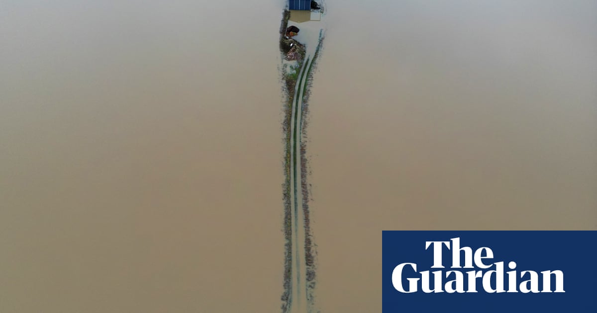
People in Nottinghamshire have been urged to consider staying with friends after river levels reached record levels.
Communities near the north of the River Trent are most at risk from flooding, according to the local authority, with residents urged to check on elderly and vulnerable residents.
Nottinghamshire county councilsaid people living in places such as Church Laneham, Marton and Ragnall should consider staying with friends.
In a series of tweets on Saturday afternoon, the council told people: “The River Trent has now reached a record peak at the Torksey Lock gauge in Nottinghamshire, with rising waters surpassing the historic levels set in the year 2000. This means that your communities are at an increased risk of flooding.”
It added: “If you live in one of the affected areas and know someone who does not have access to a computer, please share this message with them. Also, if you’re in an area at risk of flooding and have an elderly or vulnerable neighbour, please make sure to check on them.”
Meanwhile, the MP for Newark, Robert Jenrick, told Sky News: “If you see the area from above it really is biblical in terms of the level of flooding and damage that has happened.”
Meanwhile, a cold weather alert had been issued and almost 250 flood warnings across England and Wales as conditions continue to cause travel problems.
The UK Health Security Agency has issued a yellow cold weather alert for vulnerable and elderly people from 9am on Saturday until midday on Friday 12 January across England, with temperatures likely to be a few degrees below average across much of the UK, especially overnight, and ice appearing on wet ground.
The Environment Agency had 244 flood warnings, where flooding is expected, in place across England on Saturday, down from more than 300 on Friday morning. Natural Resources Wales had warnings in place on the River Wye at Monmouth and the River Ritec at Tenby.
There were a further 262 flood alerts, where flooding is possible, in place across England and nine in Wales.
Data from the Environment Agency showed almost every river in England had reached exceptionally high levels and some had reached record levels.
Heavy rain in Cambridgeshire meant rail replacement buses that were in use due to flooding on the line were unable to reach St Neots and Huntingdon railway stations for some time overnight.
Network Rail was continuing to repair damage caused by a landslip on Thursday near Arlesey, in Bedfordshire. Affected lines were estimated to reopen by early Monday with a bus replacement service in place until then.
Great Western Railway said there had been “significant disruption” to its services after flooding near Chipping Sodbury, and the line between Swindon and Bristol Parkway was expected to remain closed throughout the weekend.
The line between Theale and Taunton was likely to remain closed on Saturday, with services continuing on alternative routes.
South Western Railway, which had much of its network affected on Friday, including by a landslip in Crewkerne, Somerset, said there was a good service running on Saturday.
Roads had been closed in and around Gloucester due to flooding, and Gloucestershire police said a taxi driver had been reported for traffic offences on Friday night when he needed rescuing after getting stuck while trying to drive through flood water.
The Environment Agency said the River Severn was expected to have reached its peak at Gloucester Docks, and further upstream in Worcester, on Friday evening.
A slip road on to the A419 near Cirencester was closed on Saturday morning due to flooding, National Highways said.
In Sheffield, firefighters were called to rescue a man who fell into the swollen River Don.
The Environment Agency said “significant river flooding impacts” were expected on Saturday across parts of the Midlands on the River Trent.
It said areas of south-west England on the River Avon would also be affected, and that impacts were likely across much of England over the next five days because the ground was “completely saturated”.
The Met Office predicted Saturday would be a dry day in most areas with some sunny spells, although there would a few showers along the coast and it would feel cold, with frost and fog patches overnight.
Temperatures would drop to -4C in parts of rural south-west England on Saturday night and -6C in rural areas along the Welsh border in Shropshire and north Herefordshire on Sunday night, it said.
Sunday was forecast to remain largely dry, except for the occasional shower in south-east England early in the day, with the cold weather continuing for much of the next week.
The Met Office chief forecaster, Jason Kelly, said: “As the prevailing weather conditions will be characterised by high pressure, a good deal of settled weather is likely.
“Clearer skies and a marked reduction in precipitation are expected, although any showers that do occur are likely to be wintry in nature.”


